Rudranath Trek 2026: The Strict 2 PM Cutoff & Why It’s the Hardest Panch Kedar
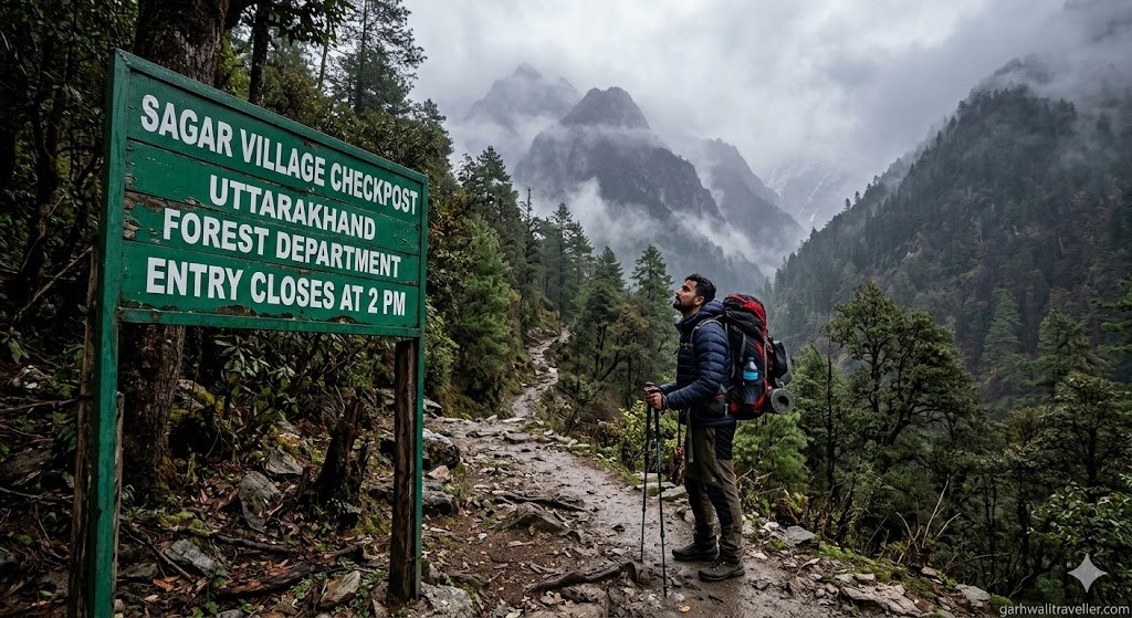
To prevent trekkers from getting stranded during afternoon cloudbursts, the Kedarnath Wildlife Division has implemented a strict 2026 safety rule: No trekker is allowed to start the Rudranath trek past the Sagar Village Forest Chowki after 2:00 PM. Additionally, all trekkers must scan the official QR code at the checkpoint and complete a mandatory digital registration before entering the forest.
The 2 PM Rule: Why the Forest Department Intervened
Unlike Kedarnath or Tungnath, the Rudranath trail has absolutely zero pony, palanquin, or helicopter services. It is a grueling 20–22 kilometer continuous vertical ascent through dense, bear-inhabited forests, making it undeniably the hardest trek in the Panch Kedar circuit.
Because of the extreme difficulty and recent spikes in stranded pilgrims, the Kedarnath Wildlife Division has implemented a hard safety mandate for the 2026 season: No trekker is permitted to cross the Sagar Village Forest Chowki after 2:00 PM.
The Monsoon Threat:
The primary reason for this strict cutoff is the volatile micro-climate on the Panar Bugyal ridge. During the summer and monsoon months, the weather pattern changes violently after 3:00 PM. Clear morning skies frequently give way to sudden high-altitude lightning, cloudbursts, and whiteout fog. Trekkers starting late in the afternoon frequently find themselves trapped in the dark, steep sections of the oak forest without shelter.
The Penalty:
The 2:00 PM barrier at Sagar Village is a hard stop enforced by stationed forest guards. Do not attempt to bypass the chowki using alternate village paths—doing so will result in heavy fines, immediate eviction from the sanctuary, and a permanent ban from the trekking route. If you arrive at Sagar after 1:30 PM, you must book a local homestay and start your ascent at 5:00 AM the following day.
The Mandatory QR Registration at Sagar Village
The days of simply writing your name in a paper register and walking into the forest are over. To track pilgrim density and manage emergency rescues, the forest department now requires full digital compliance before you take your first step.
The Digital Logbook:
At the Sagar basecamp, you must scan the official Kedarnath Wildlife Division QR code with your smartphone or log directly into kedarnathwildlife.uk.gov.in. You cannot enter the forest without completing this digital logbook and paying the ₹200 per Indian adult forest entry fee.
What You Need to Upload:
The portal requires you to upload a digital copy of a valid photo ID (Aadhaar Card, PAN, or Voter ID) and accurately map your emergency contact details. If you are trekking solo, you must list yourself as the “Lead Trekker” and provide an active emergency number of a family member not on the trail.
The Network Warning:
You must complete this registration while you still have a stable Jio or Airtel signal in Gopeshwar or at the Sagar village trailhead. Exactly 2 kilometers into the trek, the mobile network dies completely and does not return until you descend days later. Do not rely on scanning the QR code later—if your digital registration is not verified at the chowki, the guards will physically turn you back. Always take a screenshot or printout of the final permit receipt, as digital passes fail to load at the checkpoint due to the dead zone.
Route Breakdown & The “Waterless” Danger Zone
The Rudranath trail is not a casual hike; it is a serious high-altitude endurance test. Understanding the terrain breakdown is critical for your survival, especially considering the lack of mid-trail rescue infrastructure.
Explore the elevation profile of the trek below to visualize the steep climbs and the punishing descent:
Sagar to Pung/Lyuti Bugyal (The Lung-Buster):
The first 5 to 7 kilometers from Sagar Village is a relentless, steep climb through dense oak and rhododendron forests. The humidity is high, and the stone-laid path is often wet. This section is notorious for heavy leech infestations during the June and July monsoon windows.
Lyuti to Panar Bugyal (The Tree Line Ends):
As you cross Lyuti Bugyal, the dense forest abruptly ends, exposing you to the expansive, high-altitude alpine meadow of Panar Bugyal (approx. 3,400m). Panar offers a stunning 120° panoramic view of the Himalayas and is the recommended spot to pitch a tent or rent a basic shelter to acclimatize for the night.
Panar to Pitradhar (The Highest Point):
From Panar, you face the legendary “Pitra Dhar climb.” This is a grueling, sharp ridge walk of steep switchbacks that takes you to the highest point of the trek at roughly 4,000 meters. The terrain turns into fractured rocks and loose shale, and you will be battling howling, freezing alpine winds.
The Survival Bottleneck (The Waterless Zone):
The most dangerous logistical challenge of this trek occurs between Panar Bugyal, the Pitradhar pass, and Panchganga. There are absolutely no reliable natural freshwater springs on this exposed ridge. Because you are entirely exposed to direct sunlight at high altitude, dehydration sets in rapidly. You must carry a minimum of 2 to 3 liters of water per person from Panar Bugyal to survive this stretch until you reach the Panchganga streams just before the Rudranath temple.
2026 Survival Gear & Safety Precautions
Because you are entering the remote core of the Kedarnath Wildlife Sanctuary, standard walking gear will not suffice. To comply with 2026 safety standards, your loadout must include the following:
- Knee Protection is Non-Negotiable: Reaching the temple is only half the battle. The return journey is a punishing 20-kilometer continuous descent that will destroy unprepared joints. Dual trekking poles and medical-grade compression knee caps are mandatory to prevent your quadriceps and knees from giving out on the steep, rocky drop from Pitradhar.
- The Anti-Leech Arsenal: For the humid, forested stretch between Sagar and Lyuti Bugyal, standard sneakers are a hazard. You must wear high-ankle, waterproof trekking boots paired with tightly strapped gaiters. Always keep small cloth pouches filled with salt in your pockets to instantly detach leeches from your boots before they reach your skin.
- The Solo Trekking Ban: The forest department strongly advises against solo trekking in this sector. The dense, lower forest sections between Sagar and Pung Bugyal are active habitats for Himalayan Black Bears and leopards. Always trek in tightly grouped numbers, make noise while walking through dense underbrush, and never hike before dawn or after dusk.
People Also AskItinerary
To help you prepare, we have answered the most common high-intent queries trekkers have when comparing Rudranath to other Char Dham routes.
Is the Rudranath trek difficult for beginners?
The Rudranath trek is rated Moderate to Difficult and is not recommended for complete beginners. Unlike the Kedarnath Yatra, there are no mules, helicopters, or paved paths here. If you have not previously completed a moderate high-altitude Himalayan trek (such as the Valley of Flowers or Triund), the continuous 8-hour daily climbing required will be physically overwhelming.
What is the exact trekking distance and altitude?
The trek distance is approximately 20 to 24 kilometers one-way starting from Sagar Village. You begin at a base elevation of 1,650 meters, climb to a peak altitude of 4,000 meters at the Pitradhar pass, and finally descend to 3,600 meters where the temple is located. The extreme elevation gain of over 2,300 meters is what triggers Acute Mountain Sickness (AMS) in unprepared trekkers.
What is the best month to do the Rudranath trek in 2026?
There are two golden windows for this trek:
- May to mid-June: The pre-monsoon window offers clear trails, comfortable camping weather, and vibrant rhododendron blooms.
- September to October: The post-monsoon window provides the absolute clearest views of the Nanda Devi and Trishul peaks.
- Avoid July and August: The peak monsoon season transforms the route into a dangerous mudslide zone. The trails become heavily infested with leeches, and thick fog makes navigation incredibly dangerous.
Conclusion & Next Steps
The Rudranath Trek is the ultimate test of devotion and physical endurance in the Garhwal Himalayas. Respect the mountain by adhering to the 2 PM cutoff, ensure you are fully registered through the official QR portal, and never underestimate the volatile weather or the physical toll of the waterless zones.
If you are planning to cover all five shrines in the circuit, ensure your vehicle is legally permitted for mountain travel. Read our comprehensive guide on the [Char Dham Yatra Green Card Rules 2026] before driving your private car to the Sagar basecamp.