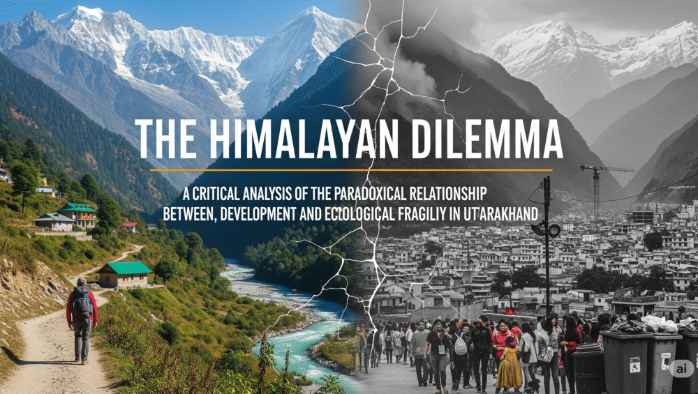
The Himalayan Dilemma: A Critical Analysis of the Paradoxical Relationship Between Tourism, Development, and Ecological Fragility in Uttarakhand
Uttarakhand, revered as the “Devbhoomi,” stands at a critical intersection where its economic vitality, largely dependent on a booming tourism industry, conflicts with the ecological integrity of its fragile Himalayan landscape. This report meticulously analyzes this central paradox, demonstrating how tourism, while a primary economic engine and a major source of employment, is simultaneously the key driver of development and large-scale construction projects that are destabilizing the state’s geologically sensitive environment. Through an examination of major infrastructure initiatives such as the Char Dham Pariyojana and the Tehri Dam, and a detailed case study of the Joshimath land subsidence crisis, this analysis identifies a systemic failure wherein a fragmented, project-by-project approach circumvents environmental safeguards. The report further investigates the cascading ecological consequences, including increased landslides, river pollution, and threats to biodiversity, and concludes with an evaluation of current policy frameworks. It ultimately proposes a shift towards a more sustainable, community-based development model that prioritizes long-term ecological preservation over short-term economic gains.
1. Introduction: The Devbhoomi at a Crossroads
1.1. Contextualizing “Devbhoomi”
Uttarakhand is a state of immense cultural, spiritual, and ecological significance. Known as “Devbhoomi,” or the “Land of Gods,” its rugged terrain is home to sacred pilgrimage sites, pristine forests, and the headwaters of vital rivers, including the Ganga and Yamuna. This profound natural and spiritual heritage has historically drawn millions of pilgrims and travelers, making tourism an intrinsic part of the region’s identity. The very foundation of the state’s economy and social fabric is built upon this reputation as a spiritual and natural haven. However, the increasing demand for access and infrastructure to support this pilgrimage and adventure tourism has initiated a period of rapid and extensive development. This is creating a fundamental conflict: the preservation of the sacred and fragile land is being jeopardized by the very industry that celebrates its existence.
1.2. The Central Thesis
This report posits that tourism is an indispensable economic engine for Uttarakhand, but the extensive infrastructure development and unregulated construction projects undertaken to support its growth are actively destabilizing a geologically sensitive and ecologically fragile region. This dynamic has created a dangerous feedback loop where economic dependency on tourism necessitates development that, in turn, escalates environmental risks. The consequences manifest as an increase in natural disasters, degradation of ecosystems, and social disruption. This analysis will demonstrate that the current developmental model, which prioritizes speed and scale, is fundamentally at odds with the principles of long-term ecological sustainability required for a Himalayan state.
1.3. Report Structure
The following analysis is structured to provide a comprehensive, multi-layered examination of this issue. Section 2 establishes tourism’s critical role as the state’s economic backbone, providing quantitative data on its contribution to GDP, employment, and investment. Section 3 delves into the primary drivers of environmental impact by analyzing key infrastructure projects, with a particular focus on the Char Dham Pariyojana and hydropower dams. Section 4 details the ecological and social consequences of this development, using the Joshimath crisis as a central case study and examining issues of river pollution and waste management. Finally, Section 5 evaluates existing policy measures and proposes a series of recommendations for a balanced and sustainable path forward.
2. Tourism as the Economic Engine of Uttarakhand
2.1. Economic Contribution and Employment
Tourism is a cornerstone of Uttarakhand’s economy, providing both direct and indirect economic benefits that are crucial for the state’s prosperity. According to various estimates, tourism contributes approximately 4.4% to the State Gross Domestic Product (GSDP). This is part of the larger services sector, which is a major contributor to the state’s economic output, accounting for over 51% of the total GSDP between 2004-05 and 2013-14.
The sector’s significance is further underscored by its employment statistics. Tourism directly creates about 4.59% of all jobs in the state. When indirect job creation is considered, this percentage rises substantially to 8.27%, highlighting the sector’s far-reaching impact across various allied industries. The state government and educational institutions have also focused on building a skilled workforce to support this growth. For instance, a study of graduates from the Uttarakhand Open University found that 64% of those with a Master of Tourism & Travel Management (MTTM) degree were employed in the tourism and hospitality sector, with no unemployment reported among MTTM graduates. This indicates a strong and consistent demand for skilled labor, reinforcing the sector’s central role in local livelihoods.
To provide a clear overview of the sector’s scale and importance, the following table summarizes key economic and tourism-related data points for Uttarakhand.
| Metric | Value | Source |
| Contribution to State GSDP | ~4.4% | |
| Direct Job Creation | 4.59% | |
| Total Job Creation (Direct & Indirect) | 8.27% | |
| Visitor Count (2023) | 5.96 crore | |
| Projected Visitors (Year-end) | >6 crore | |
| Tourism Investment Pledges (2023) | ₹47,646 crore |
Table 1: Key Economic and Tourism Statistics in Uttarakhand
2.2. Diversification and Growth of the Tourism Sector
The tourism sector in Uttarakhand is not monolithic; it thrives on a diverse range of offerings that attract a wide spectrum of visitors. This diversification is a key driver of its robust growth.
- Pilgrimage Tourism: This remains the most significant and historically important segment. Uttarakhand is home to a multitude of holy sites, with the revered Char Dham Yatra (Yamunotri, Gangotri, Kedarnath, and Badrinath) serving as its spiritual centerpiece. Other important religious destinations include Haridwar and Rishikesh, where millions of devotees flock for spiritual solace. The scale of this tourism is immense, with the state recording 5.96 crore visitors in 2023, a significant increase from 3.68 crore in 2018. This figure was expected to exceed 6 crore by the end of 2023.
- Adventure Tourism: Leveraging its mountainous terrain, the state has actively promoted adventure sports. Popular activities include trekking, peak climbing, river rafting, paragliding, camping, and skiing. The government has launched new initiatives to expand this sector, including high-level meetings to strategize on streamlining mountaineering expeditions and promoting winter tourism. For example, there are plans to reopen iconic peaks like Nanda Devi for mountaineering and keep Gangotri National Park open during winter to spot elusive wildlife. To support this, the state has invested in training local youth, with 720 individuals certified in adventure tourism skills through programs at institutions like the Nehru Mountaineering Institute.
- Wildlife and Eco-Tourism: Approximately 12% of Uttarakhand’s territory is designated as reserved forest area, housing 7 wildlife sanctuaries, 6 national parks, and numerous biosphere reserves. This rich biodiversity, which includes a high population of Bengal tigers in Jim Corbett National Park and a plethora of rare flowering species in the UNESCO World Heritage site of the Valley of Flowers, makes the state a prime destination for wildlife enthusiasts and birdwatchers.
2.3. Drivers of Growth and Investment
The state government has adopted an aggressive and multi-pronged strategy to further bolster the tourism sector. Initiatives include promoting aero and astro tourism, launching training programs for local youth, and developing new infrastructure. The government has also focused on transforming the state into a premier wedding destination as part of its “Wed in India” vision. This proactive approach has attracted significant financial commitments. The Global Investor Summit held in December 2023 secured tourism sector investments totaling ₹47,646 crore, underscoring the strong confidence in the state’s tourism potential. These efforts, combined with improving road, rail, and air connectivity , are designed to solidify tourism as the primary engine of Uttarakhand’s economic growth.
3. Infrastructure Development: The Double-Edged Sword of Progress
The rapid expansion of tourism has spurred a corresponding boom in infrastructure development, which has proven to be a double-edged sword. While intended to improve connectivity and facilitate economic growth, these large-scale projects are directly contributing to the environmental degradation of the state.
3.1. The Char Dham Pariyojana
The Char Dham Pariyojana is a flagship project that embodies this conflict. This ambitious initiative aims to construct a 900-kilometer, 12-meter-wide, all-weather road to connect the four sacred shrines of Yamunotri, Gangotri, Kedarnath, and Badrinath. The government’s justification for the project is twofold: to enhance pilgrim safety and convenience and, more critically, to provide “strategic importance” for the swift movement of troops and military equipment to the border with China. The project has received substantial political and legal backing, with the Supreme Court clearing the way for the road widening on the grounds of national security.
However, the project has been mired in significant environmental controversy. Environmentalists have consistently raised alarms about the destabilizing impact of construction on the geologically fragile Himalayan ecosystem. The most prominent concern surrounds the government’s approach to environmental clearance. To bypass the need for a comprehensive Environmental Impact Assessment (EIA), the project was deliberately divided into over 50 smaller segments. This fragmented approach allowed the project to sidestep the rigorous scrutiny typically required for large-scale infrastructure in sensitive areas, a legal and political strategy that has been heavily criticized.
The consequences of this approach are now evident. The road-widening work, which involves blasting and cutting into mountain slopes, has directly caused a surge in landslides. A study revealed an average of 1.25 landslides per kilometer along one section of the highway, a frequency that has doubled since the project began. This instability, combined with intense rainfall and seismic activity, has made the region highly vulnerable, leading to fatalities and road blockages. Furthermore, the construction has led to large-scale deforestation, with plans to fell thousands of trees in ecologically sensitive areas like the Bhagirathi Eco-Sensitive Zone (BESZ). This tree cutting removes the natural binders that hold the mountain slopes together, exacerbating the risk of avalanches and slope failures during heavy rainfall. The project is a clear example of how a development agenda, when pursued without a holistic environmental strategy, can undermine the very safety and connectivity it promises.
3.2. Hydropower and Water Resource Projects
Hydropower projects are another major component of Uttarakhand’s developmental strategy, aimed at leveraging the state’s abundant water resources for energy production. The most prominent example is the Tehri Dam, the tallest dam in India and the 13th tallest in the world, which was completed in 2006. The dam, located on the Bhagirathi River, generates 1,000 megawatts of hydroelectricity and serves purposes of irrigation and municipal water supply. However, its construction was highly controversial, sparking the “Anti-Tehri Dam movement” led by environmental activist Sunderlal Bahuguna from the 1980s to 2004. The primary concern, which continues to this day, is the dam’s location in a high seismic zone. Despite proponents claiming the dam can withstand an 8.4 magnitude earthquake, some seismologists have warned that the region is susceptible to earthquakes of 8.5 or greater, raising serious questions about the long-term safety of the structure and the downstream communities it serves.
In addition to large-scale dams, smaller hydropower projects are also contributing to the state’s environmental instability. The NTPC’s Tapovan-Vishnugad Hydroelectric Project, which involves the construction of a 12-kilometer tunnel, has been specifically linked by experts and locals to the Joshimath land subsidence crisis. The use of tunnel boring machines and blasting for the project reportedly punctured an aquifer in 2009, leading to the discharge of millions of liters of water and a subsequent weakening of the subsurface geology. This demonstrates how development projects, even those with ostensibly beneficial aims like clean energy, can have severe and unforeseen consequences when they are not designed with the unique fragility of the Himalayan geology in mind.
3.3. Unregulated Construction and Urbanization
Beyond major projects, the pervasive and unregulated construction across the state, particularly in tourist and pilgrimage hubs, is a compounding factor in environmental degradation. Experts have identified “unregulated anthropogenic activity” in ecologically sensitive areas like the Bhagirathi Eco-Sensitive Zone (BESZ) as a significant factor in exacerbating the impact of natural disasters. This includes extensive tree felling, which exposes slopes to erosion, and construction in floodplains, which disrupts natural drainage systems. These activities contribute to a higher carbon footprint and negatively impact local microclimates, further stressing the delicate Himalayan ecosystem.
4. The Cascade of Ecological and Social Consequences
The cumulative impact of large-scale infrastructure projects and unregulated development has created a cascade of ecological and social consequences, fundamentally altering the landscape and threatening the long-term viability of the region.
4.1. The Crisis of Land Instability
The Himalayas are naturally vulnerable to a range of disasters, including earthquakes, landslides, and flash floods. Development projects are acting as a significant human-induced stressor, accelerating these natural risks. A powerful, illustrative example of this phenomenon is the Joshimath tragedy.
Case Study: The Joshimath Tragedy The town of Joshimath, a critical hub for pilgrims and tourists, began experiencing widespread land subsidence, with hundreds of buildings and roads developing cracks. This crisis is not a singular event but rather a highly publicized outcome of a systemic failure in the state’s developmental approach. The town is geologically vulnerable, built not on solid rock but on the remnants of a landslide from ancient glacial debris. This unstable foundation, with its angular sediments and voids, makes the area inherently susceptible to deformation, and human-induced activities have significantly accelerated this process.
Multiple factors converged to create the crisis. The construction boom in the region burdened the already weak foundation. Concurrently, the widening of roads cleared the top layer of the hills, making the area more vulnerable to erosion. Most critically, the NTPC’s Tapovan-Vishnugad hydropower project, through drilling and blasting, is widely believed to have played a decisive role. In 2009, the project’s tunnel-boring machine punctured an aquifer, leading to a massive, multi-week discharge of groundwater that weakened the subterranean geological structure. The sudden gushing of muddy water from underground in early 2023 was seen by many as the final trigger for the latest, most severe phase of the subsidence. Despite NTPC’s denials, the convergence of a geologically unstable foundation with multiple, uncoordinated surface and subsurface development projects demonstrates a profound lack of a holistic, integrated development plan. This makes the Joshimath crisis a symbol of the dangers of prioritizing rapid development over scientific caution.
The following table provides a clear overview of the causal links between development projects and specific environmental concerns.
| Environmental Concern | Causal Development Project(s) | Specific Mechanism | Cited Source |
| Landslides | Char Dham Pariyojana | Blasting and cutting of mountain slopes, deforestation | |
| Ground Subsidence | Char Dham Pariyojana, Hydropower Projects | Pressure from heavy construction, clearing of topsoil, draining of aquifers | |
| River Pollution | Unregulated Urbanization, Tourism Infrastructure | Dumping of untreated sewage and solid waste from hotels and ashrams | |
| Habitat Loss | Char Dham Pariyojana, Other Projects | Large-scale tree cutting and deforestation in eco-sensitive zones | |
| Reduced Water Flow | Dams and Pumping Stations | Construction of dams and diversion of water for irrigation |
Table 2: Key Environmental Concerns and Their Causal Links to Development Projects
4.2. Water and Waste Management Crisis
The ecological damage extends to the state’s most vital resource: its rivers. The very act of pilgrimage, a central tenet of Uttarakhand’s tourism, has become a primary source of the pollution that threatens the Ganga and its tributaries. Experts estimate that sewage accounts for over 80% of the pollution in the Ganga, with billions of liters of untreated waste water dumped into the river daily. Major tourist hubs like Rishikesh are significant contributors, as many ashrams and hotels dump sewage and litter directly into the river, overwhelming the town’s inadequate waste treatment facilities. The city’s single municipal sewage plant, commissioned in 1984, has a capacity that is insufficient for the current population, let alone the massive influx of tourists. This creates a profound irony: the spiritual quest for purity is directly contributing to ecological contamination.
The consequences of this pollution are severe for both human health and biodiversity. The high levels of fecal coliform bacteria and other pollutants pose a serious health hazard, contributing to waterborne illnesses like typhoid and dysentery among the millions who depend on the river for their water needs. Ecologically, the pollution has caused a decline in aquatic life, including the endangered Ganges river dolphin and the softshell turtle, which are particularly susceptible to heavy metal contamination and reduced river flow from dams and pumping stations.
Solid waste management presents an equally daunting challenge. The mountainous terrain and remote locations complicate waste collection and disposal. During peak tourist season, popular destinations like Mussoorie see a massive increase in solid waste generation, from a baseline of 12 tonnes to 20 tonnes per day. This surge in waste, particularly single-use plastics, often leads to improper disposal on trails and in water bodies, or open burning, all of which disrupt fragile ecosystems and pollute pristine landscapes.
4.3. Impact on Biodiversity and Traditional Livelihoods
The development-driven environmental damage also has significant socio-economic repercussions. Large-scale deforestation and habitat loss directly threaten the state’s rich biodiversity. The broader, more insidious consequence, however, is the impact on traditional livelihoods. The promise of jobs in the tourism and construction sectors has led many locals to abandon traditional agricultural practices in favor of hospitality work, resulting in the depopulation of villages and the erosion of age-old, sustainable land-use systems. This shift leaves communities vulnerable and erodes the traditional knowledge that once governed a more harmonious relationship between the people and their environment.
5. Pathways to a Sustainable Future: Policy, Practice, and Recommendations
5.1. Government Initiatives and Their Limitations
In response to growing environmental concerns, the Uttarakhand government has initiated a number of policies aimed at promoting sustainable development. These include the establishment of Eco-Sensitive Zones (ESZs) under the Environment Protection Act of 1986 to regulate activities around protected areas. The state has also developed ambitious frameworks such as the Uttarakhand Renewable Energy Policy 2023, which targets a 50% renewable energy share by 2030, and the Uttarakhand Climate Action Plan. The government has also introduced innovative strategies like the
Nau Sutra (nine principles) and a proposed Eco Balance Index to measure the performance of policies on both ecological and economic axes.
Despite the promising nature of these policies, a significant gap remains between their stated goals and their on-the-ground implementation. The Bhagirathi Eco-Sensitive Zone, for instance, has been politically contested as “anti-developmental,” and the very large-scale projects it was meant to regulate, such as the Char Dham road widening, have proceeded in spite of these regulations. Similarly, while the state is building new sewage treatment plants, the current capacity remains “insufficient” to handle the waste generated by the existing population and the massive tourist influx, rendering the efforts inadequate to tackle the problem. This disconnect between policy and practice demonstrates that even well-intentioned frameworks risk becoming “paper tigers” without robust enforcement mechanisms.
5.2. The Promise of Community-Based and Sustainable Tourism
A more sustainable model for development lies in a shift away from mass tourism towards a community-based approach. Community-Based Tourism (CBT) is an alternative development style that places local hosts at the center of decision-making, ensuring that the benefits of tourism are distributed equitably across the community. It provides an economic alternative to environmentally damaging livelihoods like logging or mining, empowering locals to become stewards of their natural resources.
Examples of this approach are already demonstrating success in Uttarakhand. The Energy and Resources Institute (TERI) has undertaken projects in the Nainital and Champawat districts to promote sustainable agriculture and livelihoods through eco-friendly techniques like polyhouses and solar dryers, and by providing homestay training for local communities. These initiatives not only enhance local economic well-being but also preserve biodiversity and build community engagement. By focusing on eco-friendly accommodations, responsible trekking, and supporting local businesses, this model fosters a deeper connection between visitors and the environment, encouraging a culture of conservation.
5.3. Concluding Recommendations for a Balanced Approach
Based on the preceding analysis, the following recommendations are proposed to help Uttarakhand navigate the complex trade-off between economic development and ecological preservation:
- Impose a Moratorium on Large-Scale Projects in Fragile Zones: A temporary but strict halt on major infrastructure projects (e.g., wide roads, large dams) in geologically sensitive areas is necessary until a comprehensive, independent, and scientifically-sound carrying capacity study can be completed for each valley. This would provide the foundational data needed for informed, sustainable planning.
- Strengthen and Enforce the Regulatory Framework: Environmental laws must be fully and transparently enforced. Practices like segmenting projects to bypass Environmental Impact Assessments should be prohibited. An independent, high-powered oversight body with the authority to audit and enforce regulations is essential to ensure accountability and prevent political or economic priorities from overriding ecological safeguards.
- Invest in Decentralized, Eco-Friendly Infrastructure: The focus should shift from large-scale, high-impact projects towards smaller, decentralized solutions that are better suited to the mountainous terrain. This includes constructing intermediate-width roads, which reduce ecological impact , and investing in local, community-run waste management and sewage treatment facilities that can handle the specific demands of tourist towns.
- Promote and Incentivize Sustainable Tourism: The state should actively promote and provide incentives for tourists and businesses to adopt sustainable practices. This could include offering certifications for eco-friendly accommodations, launching public awareness campaigns to reduce plastic waste and promote “Leave No Trace” principles, and scaling up successful community-based tourism models. This approach would re-align tourism with conservation, ensuring that the state’s economic engine is powered by the very natural and cultural heritage it is meant to preserve.
6. References
Prepdata. (n.d.).
Uttarakhand Tourism. Retrieved from https://www.prepdata.org/dashboards/uttarakhand-tourism
Prepdata. (n.d.).
Uttarakhand Tourism – PREPdata. Retrieved from https://www.prepdata.org/dashboards/uttarakhand-tourism#:~:text=Tourism%2C%20according%20to%20some%20estimates,05%20to%202013%2D14).
Interes Journals. (n.d.).
Growth of Tourism Industry in Uttarakhand. Retrieved from https://www.interesjournals.org/articles/growth-of-tourism-industry-in-uttarakhand.pdf
Uttarakhand Open University. (n.d.).
Employment Survey of Tourism Students. Retrieved from https://uou.ac.in/downloads/placement/Employment-Survey-of-Tourism-Students.pdf
Peak Adventure Tour. (n.d.).
Top Tourist Places & Uttarakhand. Retrieved from https://www.peakadventuretour.com/uttarakhand-tourism.html
Corbett National Park. (n.d.).
Uttarakhand Tourism. Retrieved from https://www.corbett-national-park.com/uttarakhand-tourism.html
DOAJ. (n.d.).
The historical perspectives of pilgrimage tourism in the Uttarakhand Himalaya. Retrieved from https://doaj.org/article/79600147071c469e868133144cdeb892
2lafz. (n.d.).
Pilgrimage Places in Uttarakhand: Explore the Spiritual Sites. Retrieved from https://2lafz.com/pilgrimage-places-in-uttarakhand-explore-the-spiritual-sites/
Times of India. (2025, July 16).
High-level meeting held to expand adventure tourism and mountaineering in Uttarakhand. Retrieved from https://timesofindia.indiatimes.com/city/dehradun/high-level-meeting-held-to-expand-adventure-tourism-and-mountaineering-in-uttarakhand/articleshow/122580058.cms
The Times of India. (2025, November 20).
Uttarakhand’s tourism boom: 6 crore visitors driven by adventure, pilgrimage and ecology expected by year-end. Retrieved from https://timesofindia.indiatimes.com/india/uttarakhands-tourism-boom-6-crore-visitors-driven-by-adventure-pilgrimage-and-ecology-expected-by-year-end/articleshow/115081835.cms
Invest Uttarakhand. (n.d.).
Infrastructure Development in Uttarakhand. Retrieved from https://investuttarakhand.in/infrastructure-development-in-uttarakhand/
Sriram’s IAS. (n.d.).
Char Dham Highway Project: Benefits and Concerns. Retrieved from https://www.sriramsias.com/upsc-daily-current-affairs/char-dham-highway-project-benefits-and-concerns/
ForumIAS. (n.d.).
Impacts of the Char Dham Highway Project. Retrieved from https://forumias.com/blog/impacts-of-the-char-dham-highway-project/
Wikipedia. (n.d.).
Tehri Dam. Retrieved from https://en.wikipedia.org/wiki/Tehri_Dam
Unacademy. (n.d.).
Dams in Uttarakhand. Retrieved from https://unacademy.com/content/bank-exam/study-material/general-awareness/dams-in-uttarakhand/
Times of India. (n.d.).
Unregulated activity added to Dharali devastation: Experts. Retrieved from https://timesofindia.indiatimes.com/city/dehradun/unregulated-activity-added-to-dharali-devastation-experts/articleshow/123127074.cms
Hindustan Times. (n.d.).
Disasters highlight trade-offs for construction. Retrieved from https://www.hindustantimes.com/india-news/disasters-highlight-trade-offs-for-construction-101754507217217.html
EOS. (n.d.).
A possible cause of the 5 August 2025 landslide is the failure of a large body of glacial material high in the valley above the village. Retrieved from https://eos.org/thelandslideblog/tharali-2
Encardio. (n.d.).
Monitoring of Narendra Nagar Uttarakhand landslide. Retrieved from https://www.encardio.com/blog/monitoring-of-narendra-nagar-uttarakhand-landslide
Hindustan Times. (n.d.).
From polluted Ganga to drying springs: 5 environmental challenges before Uttarakhand. Retrieved from https://www.hindustantimes.com/dehradun/from-polluted-ganga-to-drying-springs-5-environmental-challenges-before-uttarakhand/story-pQUi7aCpgcpxhIGd0dUadM.html
Vice. (n.d.).
Yoga tourism pollution sacred hometown. Retrieved from https://www.vice.com/en/article/yoga-tourism-pollution-sacred-hometown/
YouTube. (n.d.).
Joshimath is sinking. The quaint town, which doubles as a pitstop for pilgrims…. Retrieved from https://www.youtube.com/watch?v=pSxHw78O7YU&pp=0gcJCfwAo7VqN5tD
India Today. (n.d.).
Joshimath sinking landslide debris uttarkhand tragedy bjp indian army bro. Retrieved from https://www.indiatoday.in/interactive/immersive/joshimath-sinking-landslide-debris-uttarkhand-tragedy-bjp-indian-army-bro
YouTube. (n.d.).
experts believe that the hydro projects by National Thermal Power Corporation…. Retrieved from https://www.youtube.com/watch?v=pSxHw78O7YU&pp=0gcJCfwAo7VqN5tD
SANDRP. (n.d.).
Systemic failures at the root of Joshimath disaster. Retrieved from https://sandrp.in/2023/02/11/systemic-failures-at-the-root-of-joshimath-disaster/
Al Jazeera. (n.d.).
Demolitions begin in India’s ‘sinking’ Joshimath, hundreds moved. Retrieved from https://www.aljazeera.com/news/2023/1/10/demolitions-begin-in-indias-sinking-joshimath-hundreds-moved
Press Information Bureau (PIB). (n.d.).
All construction activities have been stayed by the State Government…. Retrieved from https://www.pib.gov.in/PressReleasePage.aspx?PRID=1943203
Ghoom Uttarakhand. (n.d.).
Sustainable Tourism in Uttarakhand Eco-Friendly Travel Tips for 2025. Retrieved from https://ghoomouttarakhand.com/sustainable-tourism-in-uttarakhand-eco-friendly-travel-tips-for-2025/
IJSSET. (n.d.).
The Indian government responded by designating some places in Uttarakhand as Eco-Sensitive Zones…. Retrieved from https://www.ijset.in/wp-content/uploads/IJSET_V12_issue5_753.pdf
IGNFA. (n.d.).
An Evaluative Discussion on Eco-Sensitive Zones. Retrieved from https://www.ignfa.gov.in/publications/an-evaluative-discusion-esz-paper.pdf
MoEF. (n.d.).
Zonal Master Plan for the Bhagirathi Eco-Sensitive Zone. Retrieved from https://moef.gov.in/uploads/2017/06/Bhagirathi%20Eco%20zone%20-%20ZMP%20comments_0.pdf
Down to Earth. (n.d.).
When the Himalayas lose: Assessing Char Dham Pariyojana judgment. Retrieved from https://www.downtoearth.org.in/environment/when-the-himalayas-lose-assessing-char-dham-pariyojana-judgment-80755
NDTV. (n.d.).
Char Dham Project: Supreme Court Clears Widening Char Dham Roads For “National Security”. Retrieved from https://www.ndtv.com/india-news/char-dham-project-supreme-court-agrees-with-centre-on-road-widening-says-national-security-border-security-concerns-need-to-be-met-2649944
GN Publication. (n.d.).
RIVER GANGA ROUTINELY RECEIVING SEWAGE FROM. Retrieved from https://gnpublication.org/index.php/ans/article/download/97/89#:~:text=The%20major%20sources%20of%20sewage,well%20as%20industries%2C%20urbanization%20etc.
Wikipedia. (n.d.).
Ganges. Retrieved from https://en.wikipedia.org/wiki/Ganges
Waste Warriors. (n.d.).
Effective Waste Management Services Mountain Towns Focus Indian Himalayan Region. Retrieved from https://wastewarriors.org/effective-waste-management-services-mountain-towns-focus-indian-himalayan-region/
ResearchGate. (n.d.).
Solid waste generated in major towns of Uttarakhand. Retrieved from https://www.researchgate.net/figure/Solid-waste-generated-in-major-towns-of-Uttarakhand_tbl2_364313134
Ganga Action. (n.d.).
Sewage & Waste Management. Retrieved from https://gangaaction.org/actions/issues/sewage-waste-management/
Wikipedia. (n.d.).
Pollution of the Ganges. Retrieved from https://en.wikipedia.org/wiki/Pollution_of_the_Ganges
Ghoom Uttarakhand. (n.d.).
Sustainable Tourism in Uttarakhand Eco-Friendly Travel Tips for 2025. Retrieved from https://ghoomouttarakhand.com/sustainable-tourism-in-uttarakhand-eco-friendly-travel-tips-for-2025/
ETGovernment. (n.d.).
Uttarakhand’s Green Transition: A Blueprint for Sustainable & Inclusive Development. Retrieved from https://government.economictimes.indiatimes.com/blog/uttarakhands-sustainable-development-a-model-for-balancing-economy-and-ecology/121695073
Cushman & Wakefield. (n.d.).
Strategies for Sustainable Development in Uttarakhand. Retrieved from https://assets.cushmanwakefield.com/-/media/cw/apac/india/insights/phdcci-report-2025.pdf?rev=93c605bfaf644e53b363694324a84974#:~:text=There%20are%20several%20policies%20and,integrated%20roadmap%20for%20carbon%20neutrality
TERI. (n.d.).
Grassroots Climate Action in Uttarakhand: Partnerships, Participation, and Progress. Retrieved from https://www.teriin.org/article/grassroots-climate-action-uttarakhand-partnerships-participation-and-progress
Publishing India Group. (n.d.).
Community Based Tourism Development: A Case-study of Eco Village Sari in Kedarnath Sanctuary Region. Retrieved from http://www.publishingindia.com/GetBrochure.aspx?query=UERGQnJvY2h1cmVzfC80NDUucGRmfC80NDUucGRm
Satoyama Initiative. (n.d.).
COMDEKS Project: Himalayan State of Uttarakhand, India. Retrieved from https://satoyamainitiative.org/case_studies/comdeks-project-himalayan-state-of-uttarakhand-india/