Rishikesh Uttarakhand – Top Places to Visit, Things to Do
Rishikesh – The Yoga Capital of the World
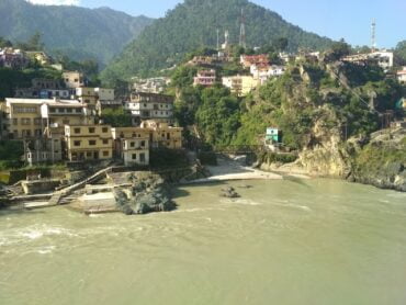
Rishikesh is the only place in the world-famous for adventure sports, Yoga, and tourism. It is located on the bank of the Ganga River in the Shivalik range of Uttarakhand. Rishikesh is located at a distance of just 20- 25 Km from Dehradun. Rishikesh is the hub of yoga, meditation, and spirituality.
Rishikesh has also become a popular and famous destination for adventure sports like river rafting, Bungee Jumping, Rock climbing, camping, hiking, and many more which attracts tourists not only from India but also from all over the world.
Mythology About Rishikesh
Rishikesh is widely known as one of the Holiest places in India, it is associated with many legends & mythological tales. The first myth says that once upon a time, Risi Raibhya performed a hard penance on the banks of the river Ganga. Lord Vishnu was impressed by his strict penance and appeared in front of them as “Hrishikesh” meaning “Lord of Senses” in the Sanskrit language. After that, the place became popular by the name Hrishikesh (another name of Lord Vishnu) and then later was named “Rishikesh”. In Kedar Khand of Skand Purana, there is the existence of Indrakund at that place.
The second myth tells that Lord Rama came there thousands of years ago for meditation and for annihilating Ravana with his younger brother Lakshamana who crossed the river Ganga by a jute rope bridge which is named Lakshmana Jhoola. In 1889 the bridge was reconstructed and replaced by steel and Iron rope suspension. A similar bridge was made in 1986 which was named Ram Jhoola. Also, there are many ancient temples in Rishikesh made by Adi Guru Shankaracharya.
There are several ancient temples, Ashrams in Rishikesh which are related to our historical & mythological background. A dip in the holy water of the river Ganga cleanses all the sins(bad works paap) of a person.
Rishikesh Travel Destination
Rishikesh is a medium-populated town famous for Yoga & Meditation. It is the gateway to the Himalayan Ranges and is the bank of the river Ganga and the ideal destination for adventure sports and camping and enjoying holidays.
Rishikesh is situated at an altitude of 356 meters above sea level and is distinct with three areas Muni- Ki- Reti, Rishikesh & Swargashram. It is located at the foothills of the Himalayan region of Uttarakhand and is easily accessible by road. It is the starting point of exploring the Himalayan region.
Rishikesh – Meditation & Yoga destination
Thousands of years ago, saints came there for meditation & spirituality because this place was fulfilled with peace. After that, Rishikesh became the birthplace of Yoga, Meditation, Spirituality, Spa therapies, and Ayurveda.
Rishikesh, also known as “The world Capital of Yoga” has many Yoga centers which attract tourists all over the world. It is believed that meditation and a dip in the flow of Ganga bring one closer to the Moksha.
Activities to do in Rishikesh
Yoga & Meditation: Rishikesh is also considered the “Yoga Capital of the World”. Tourists from all over the world come here for meditation and spirituality and to find inner peace.
Rafting: Rafting in Rishikesh is popular all over India where huge waves of Ganga make it a more popular adventure sport in Rishikesh. Adventure and rafting seekers come here in large amounts to feel the thrill of the river Ganga.
Adventure Sports: Apart from rafting there are many other adventure sports which are also the attraction point for tourists in Rishikesh like Bungee Jumping, flying fox, Kayaking, Mountain Biking, Rock climbing, etc.
For what Rishikesh is famous?
- Rishikesh is famous for Yoga, Meditation, Rafting, Adventure Sports, Bungee Jumping, Pilgrimage, Tourism, Temples & Ashrams.
- Rishikesh is recommended for all people as Family, Couples, Friend Groups, Solo, Kids, and Foreigners.
- Rishikesh is a popular destination for the following activities: Rafting, Adventure Sports, Bungee Jumping, Pilgrimage, Tourism, Temples, Yoga & Meditation, Spirituality, Peace, Trekking and Mountain climbing, Hiking, New Year and Christmas, and Weekend trip.
Overview Rishikesh
- Temperature: 29(Max) and 14(Min) in Celcius
- Location: Dehradun, Garhwal
- Stay(Recommended): 2 days(Min)
- Nearest Railway Station: Haridwar, Dehradun(22 Km)
- Nearest Airport: Jolly Grant Airport Dehradun(20 Km)
- Famous for: Yoga, Meditation, Adventure Sports and Rafting, Temples and Ashrams
- Best time to visit: January – December(All the months of the year are recommended)
Rishikesh’s distance from Delhi, India is 250 Km and it will take up to 5 Hours 49 Minutes approx
Note: River Rafting at Rishikesh closes in the monsoons due to high rainfall in the hilly areas, as a result, the water level of Ganga increases.


